Image courtesy of Carlye Thornton, Senior Specialist, Marketing & Communications for University Libraries and ITS.
by Rachel DeShong, Special Event Coordinator and Map Curator
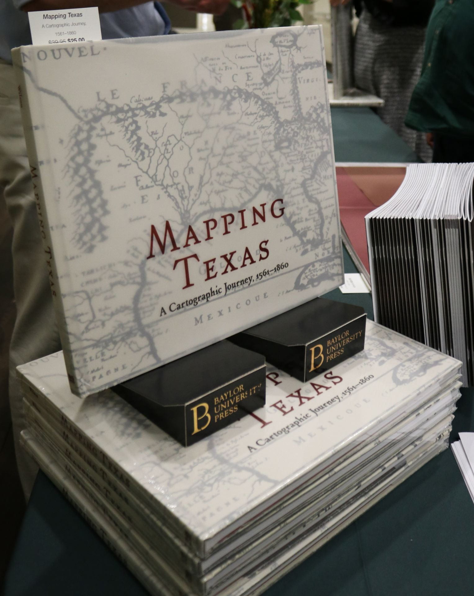
On November 14th, The Texas Collection hosted its annual fall lecture which focused on the newly published book Mapping Texas: A Cartographic Journey, 1561 to 1860. This project, published by Baylor University Press, was a collaborative work written by John S. Wilson, Baylor’s Interim Dean of Libraries and Director of The Texas Collection, Sierra M. Wilson, Print Production Coordinator for the University of Chicago Press, and Rachel DeShong, the Map Curator at The Texas Collection. Mapping Texas features 44 full color maps from the Frances C. Poage Map Room in the style of a large, coffee-table book. At the lecture, the authors explored the origins of the iconic boundary of Texas, highlights from some of the more prominent maps, and the practical and artistic aspects of map cartouches.
The first map the speakers analyzed was Nueva Hispania Tabula Nova[1], 1561. This is one of the earliest maps in our collection and is one of the first maps that accurately depicts the Texas coastline. The map is notable because of the various editions – also referred to as “states” – that exist. The third edition, which The Texas Collection owns, is distinguished by the introductions of new place names and the illustration of a ship in the middle of the Pacific Ocean.Continue Reading
Bring a sweater. The collections here are kept at 65°, which means it’s chilly. Even on the hottest 110° days, you’ll probably need an extra layer, but it’s for the good of the collections, so it’s worth it. There are really old books, maps, and other valuable pieces of history on paper, so it’s important to do our best to preserve them.
Texas has really weird towns. The Texas Collection has a vast map collection, housing about 14,000 maps of mostly Texas, and I worked with over 2,500 of them. Scranton, Movie Mountain, and Blanket were some of my favorites. You can take a tour of Europe if you’re interested, including towns like London, Paris, Oxford, Dublin, Edinburg, Florence, and Athens. If you don’t believe me, just head to the map room in The Texas Collection. The collection houses a very extensive array of maps, and another thing you might not know is how beautiful they are! From really old historical maps of the U.S. and Texas to maps of Waco, many research needs can be met in the map room.
We are a photogenic school. If you need any historical pictures of Baylor or Waco, The Texas Collection can help you out. Maybe you work for The Lariat, maybe you need vintage fashion inspiration, or maybe you’re just upping your Instagram game – regardless the reason, the archives are your gold mine! If you are like me, and you aren’t the first in your family to come to Baylor, it’s especially fun to see photos of Baylor and Waco when our parents and grandparents were here.
You should start your research paper here. Not only are the resources available valuable for your research, but the reading room is a quiet space for any studying needs. There is always someone at the desk to help you, and it’s a nice change of pace from the other libraries that can be crowded at different points throughout the semester.
If you leave when it’s closing time, you get to hear the bells. Although Carroll Library closes at 5:00pm, one of the best parts of my days this summer has been on the walk back to my car. I try to leave right on time just to to hear the bells because it’s a fun reminder of how the history housed in The Texas Collection is still reflected throughout Baylor today.
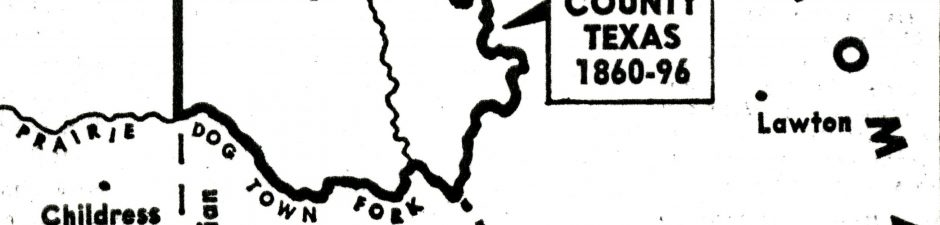
As the United States acquired significant territory through the 1840s and 1850s, borders between newly admitted states followed boundaries established in the Adams-Onís Treaty of 1819. Border disputes between states emerged as a result of several inaccuracies in Melish’s map. One particular hotbed of contention was the Red River area.
According to the Adams-Onís Treaty, the boundary between the Spanish colony of Mexico and the United States began at the mouth of the Sabine River, went north to the 32nd degree latitude line where it intersected with the Red River, and then followed that river west until it reached the 100th Meridian. However, there were several problems with Melish’s depiction of the area. Firstly, his 100th Meridian was off target by nearly 90 miles. Secondly, Melish only recorded a single fork in the Red River while, in actuality, there were two. These errors became problematic in deciphering the border between Texas and the Indian Territory (Oklahoma).
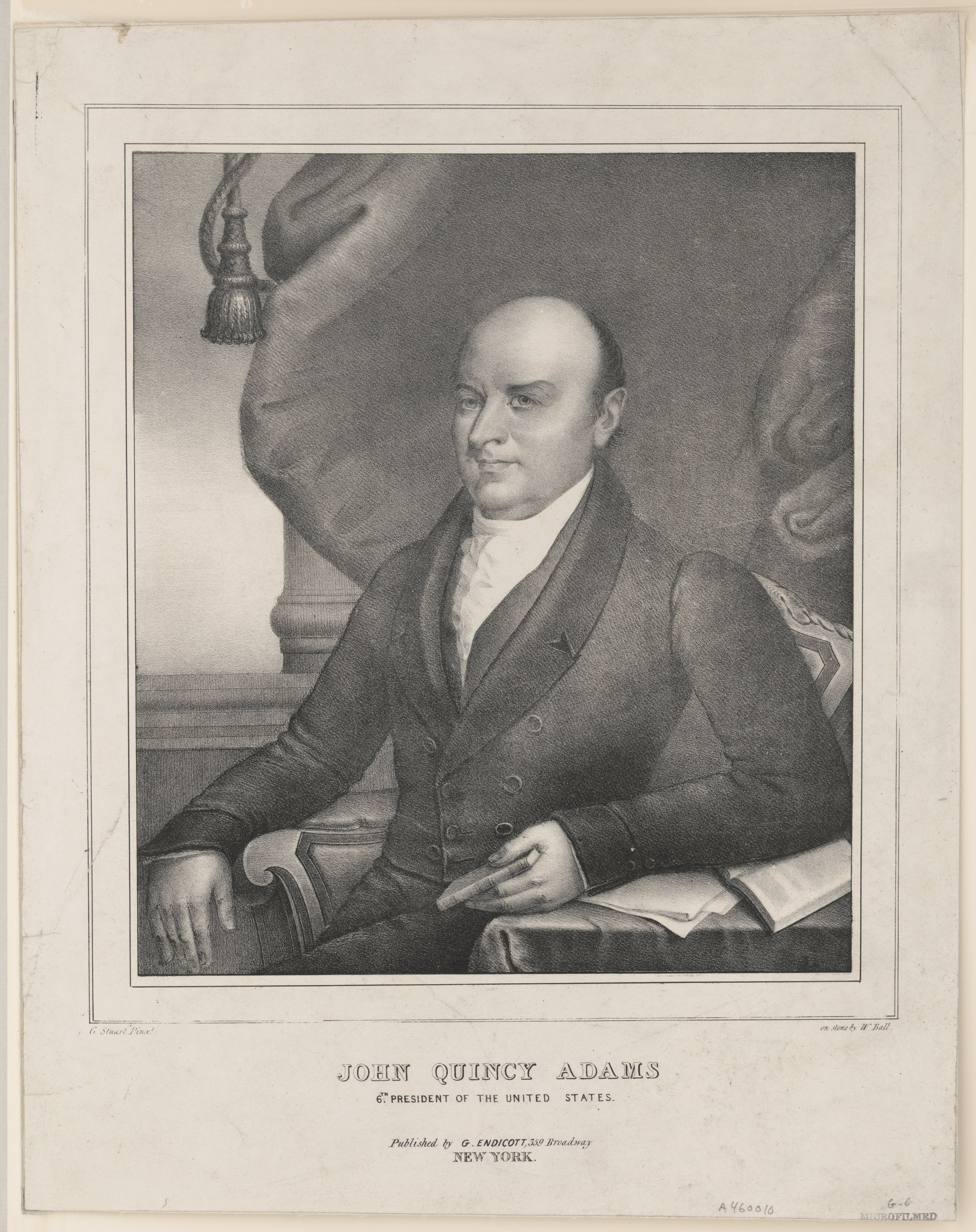
John Quincy Adams Popular Graphic Arts, Prints & Photographs Division, Library of Congress, LC-DIG-pga-10486.
The Adams-Onís Treaty of 1819 was the culmination of prolonged boundary disputes between Spain and the United States. Spain was attempting to retain their colonial empire in the Americas which was crumbling at the hands of revolutionaries. The United States, on the other hand, was rapidly expanding its borders but was highly concerned about the British presence in Florida. Although officially recognized as Spanish territory, Florida was heavily influenced by British mercantilism. During the War of 1812, British naval vessels used Florida as a launching point for attacks on New Orleans and other ports of the American South. Moreover, the United States had growing concerns regarding the number of runaway slaves and Native Americans residing in Florida. For these reasons, both Spain and the United States sought a mutually beneficial compromise with Florida at the heart of the deal.
Luis de Onís y Gonzalez was the Spanish Foreign Minister who negotiated the treaty. Arriving in Washington, D.C. in October 1809, he was not recognized as a legitimate government representative at first due to a civil war in Spain. It was not until December 1815 that the United States formally accepted Onís’ credentials. Although negotiations commenced under Secretary of State James Monroe (before he became the fifth president), most of the results occurred under Secretary of State John Quincy Adams (who would become the sixth president.) After the finer points were settled, the Adams-Onís Treaty accomplished two of the Unites States’ major priorities:
Spain ceded Florida to the United States.
The United States now claimed a solid, international boundary extending from the American South to the Pacific Northwest.
by Rachel DeShong, Special Event Coordinator and Map Curator
“Recalculating” is a term that many of us are far too familiar with. We hear it when the GPS navigation system on our phone is telling us how to get from Point A to Point B, but we somehow managed to miss the turn. It is hard to imagine a time when maps were unable to give accurate directions in real time. Modern maps are expected to be flawless and up-to-date. So, what happens when maps are wrong?
A New Map of the North Parts of America Claimed by France Under Ye Names of Louisiana, Mississippi, Canada, and New France with Ye Adjoyning Territories of England and Spain. 1720. Drawer 1 Folder 3, The Texas Collection, Baylor University.
Map of the proposed layout for the town of New Birmingham. The streets were named after major U.S. cities, Texas towns, and a few of the major investors in the project.
In the early 1880s, Alabama native and sewing machine salesman Alexander B. Blevins envisioned a town in East Texas that would rival the iron production of Birmingham in his home state. While traveling through the eastern part of Texas, he encountered significant iron ore deposits and identified a potential town site two miles east of Rusk, between Palestine and Nacogdoches. Blevins secured financial backing for “The Iron Queen of the Southwest” from his brother-in-law Gen. W. H. Hammon, a prominent Calvert lawyer, and several other wealthy investors from New York. The town, called New Birmingham, sold its first lot in 1888 and by 1891 it boasted around 2,000 residents, two working furnaces, a train depot, electric light station, carriage shop, ice manufacturer, pipe and bottling works, brick yard, and the largest hotel outside of Dallas, San Antonio, Houston, and Galveston. Most of these buildings were built with brick, demonstrating the founders’ intention for the town’s permanence.
The Texas Collection recently discovered two pieces of promotional material associated with New Birmingham: a map of the proposed layout of the town along with existing homes and buildings as of August 1891 and a promotional booklet with details about the town’s benefits and business opportunities, which can be accessed here: here and here. Yet, by 1893, New Birmingham was deserted and the Cherokee County Banner, a local newspaper, declared that the “Iron Queen was dead.” All the town’s residents left except for a single caretaker and his wife who lived in the Southern Hotel, but even that structure burned to the ground in 1926. Most scholars point to a lack of initial capital for the venture compounded by the Panic of 1893, an explosion that ruined one of the furnaces, and the unfavorable Alien Land Act passed by Texas governor James Hogg as likely causes of the city’s quick demise. A legend survives, however, that tells a significantly different and more dramatic reason for the total destruction of New Birmingham, Texas.
The most impressive structure in New Birmingham was the Southern Hotel. It housed such distinguished guests as Texas Governor James Hogg, railroad magnate Jay Gould, and former President Grover Cleveland.
According to the legend, Gen. W. H. Hammon and his wife Ella lived in the Southern Hotel. Ella had bright red hair and was considered the most beautiful woman in the town. In 1890, grocer S. T. Cooney and his wife, who was also very beautiful, moved to the town. Mrs. Hammon supposedly became incredibly jealous and she and her husband began spreading rumors around the town about Mrs. Cooney’s conduct. S. T. Cooney filed a slander suit against Gen. Hammon, but instead of waiting for the court to handle the conflict, he took matters into his own hands and shot Hammon to death in the middle of the street on July 14, 1890. Mrs. Hammon witnessed her husband’s death and called on the townspeople to lynch Cooney, but public sentiment about the incident was divided. After unsuccessfully attempting to convince the defense attorney to drop Cooney as a client, she ran through the streets of New Birmingham with her red hair flowing and cursed the town, calling on God to “leave no stick or stone standing in this mushroom town.”
This photo shows a single brick wall from the high school, the only structure remaining from the town of New Birmingham. The rest of the site has been overgrown by the surrounding East Texas forest.
Although the dramatic details of the legend cannot be proven, the slander suit and murder were reported in several Texas newspapers. The Galveston Daily News closely followed the trial and Cooney was found guilty of manslaughter and sentenced to two years in the state penitentiary on July 11, 1891. When the furnace exploded and the financial crisis hit New Birmingham in 1893, many townspeople recalled the curse of Mrs. Hammon and believed it to be a bad omen. Unlike other ghost towns in Texas, nothing remains to mark the place where this magnificent boomtown once stood. Most of the bricks from the businesses and homes were carted away during World War I or used to erect structures in the nearby town of Rusk. In a sense, Mrs. Hammon’s curse came true after all.
Bibliography
“Gen. Hammon Killed.” Dallas Morning News. July 15, 1890. America’s Historical Newspapers, Readex. accessed June 14, 2017.
Long, Christopher. “New Birmingham, Texas” A New Handbook of Texas. Vol. 4. Austin, TX: Texas State Historical Association, 1996.
“Made It Manslaughter.” The Galveston Daily. July 11, 1891. Newspapers.com accessed June 14, 2017.
“New Birmingham.” Cherokee County History. John Allen Templeton, ed. Jacksonville, TX: Cherokee County Historical Commission, 1986.
New Birmingham Iron and Improvement Co. of Texas. New Birmingham, Cherokee County, Texas. Chicago: Rand, McNally, and Co., 1891.
New Birmingham, Texas. Chicago: Rand, McNally, and Co., 1891.
New Birmingham, Texas [Vertical File] The Texas Collection, Baylor University.
Roach, Hattie Joplin. A History of Cherokee County. Dallas, TX: Southwest Press, 1934.
by Allie McCormack, Rare Books Catalog Librarian for Baylor Libraries
For this installment of Cataloger’s Corner, I’d like to share with you one of the oldest books held at The Texas Collection: a 1562 printing of Ptolemy’s Geographia. Not only is the book itself quite old, but it was acquired very early in the history of The Texas Collection through a unique program called the McGregor Plan for the Encouragement of Book Collecting by American College Libraries that operated during the 1930s.
The Geographia, sometimes called the Cosmographia, is special for many reasons. A revision of a now-lost atlas by Marinus of Tyre, it was compiled around 150 CE by Claudius Ptolemy using new principles and additional Roman and Persian sources. It was translated into Arabic in the 9th century and Latin in 1406, going through many editions in each language.
A large portion of Ptolemy’s work was dedicated to cartographic principles. Specifically, he improved the treatment of map projections—the system that lets cartographers map a round object like the globe onto a flat plane like a map—and gave readers instructions on how to recreate his maps. He also provided latitude and longitude coordinates for all the places and geographical features in the book.
Of course, the ancient Romans were only aware of about a quarter of the globe; Ptolemy’s European maps didn’t include Scandinavia, for example, let alone North or South America. Later editions added additional maps to represent new knowledge. During the Age of Exploration, when Europeans launched extensive overseas exploration parties, new editions included as many as 64 regional maps. Old maps also had to be altered to reflect these discoveries.
What I want to focus on here is one of the more curious geographical features mapped in the Geographia: the island of Taprobana. Don’t worry if that name doesn’t sound familiar: this place was known to the Greeks before the time of Alexander the Great, but modern scholars have no idea to what land it corresponds. On the map above, based on Ptolemy’s original world map, it is situated south of India and might represent Sri Lanka. However, on the map to the left, which is based on geographical knowledge of the 1560s, Sri Lanka is clearly marked with a Z (Zeelan, a strange Latinization of the Portuguese Ceilão, from whence the English term Ceylon). Instead, the position of Taprobana might correlate with the island of Sumatra.
But wait! A map of the area between the Adaman Sea and the Gulf of Thailand has Sumatra marked as Camatra. Below it is the island of Java (marked Iava, as Latin orthography often did not include the letter J). If Taprobana isn’t Sri Lanka or Sumatra, what is it?
Some scholars think Taprobana is a phantom island, a geographical feature that shows up on maps for many years until subsequent explorations of the area fail to find the land mass. Others think the ancient Greeks and Romans simply miscalculated the location of Sri Lanka on their maps. They use linguistic evidence to bolster their argument: according to the Mahavamsa, a 5th century CE document written in the Pali language that chronicles the history of the kings of Sri Lanka, the legendary Prince Vijaya named the land Tambapanni (“copper-red hands” or “copper-red earth”) because his followers’ hands were reddened by the soil on the island.
Perhaps later cartographers kept both Sri Lanka and Taprobana on their maps because they respected Ptolemy’s authority. Indeed, until the scientific revolution, previous scholarship was so revered that new discoveries which repudiated established fact were viewed with suspicion, or shoehorned into existing systems of thought even when there were obvious contradictions. Or, maybe the cartographers simply couldn’t rule out the existence of Taprobana and included it in their maps in case it was one day discovered. It remains a mystery.
Baylor University holds other works by Ptolemy, which you can see here. If you’re interested in other early geographical works, click here. If you’d specifically like to see early atlases, follow this link.
In late November 1941, the most respected authority on materials relating to Texas visited Baylor University’s Texas Collection as part of his duties as a member of the McGregor Fund Committee. Thomas W. Streeter applauded The Texas Collection’s holdings in a letter to Guy B. Harrison and generously donated several items from his personal collection to the library.
Thomas Streeter was a successful businessman from the Northeast who harbored an interest in the collecting of rare materials relating to American history. His business ventures took him to Texas, which he utilized as an opportunity to add maps, broadsides, and various other items to his collection. By the end of his life, Streeter had assembled the largest known private collection of Texana.
Streeter meticulously compiled and published his Bibliography of Texas 1795-1845 in three volumes between 1955 and 1960. The work contained more than 1,600 entries including maps, novels, and musical scores along with pamphlets and government documents. His bibliography is widely considered the foremost authority on early Texas imprints and The Texas Collection owns many of the items he included.
Five of these items came from Streeter personally in 1941 after his visit to The Texas Collection. He came to Waco as a representative of the McGregor Plan, a program Baylor University participated in throughout the late 1930s and early 1940s. The program, founded by philanthropist and bibliophile Tracy W. McGregor, assisted libraries not located near major institutions to purchase rare books they would otherwise not be able to access. The school paid $500 each year and the McGregor Plan matched their funds and acted as the go-between for the schools and rare book dealers. Streeter served as a member of the committee which administrated the program after McGregor’s death in 1936.
A new map of Texas, with the contiguous American & Mexican states (1836)
The Texas Collection acquired significant rare Texas materials through the library’s participation in the McGregor Plan. After his visit, Streeter sent several items he felt would fill in the gaps he perceived in The Texas Collection’s holdings. He donated an 1836 map of Texas entitled “New Map of Texas with the Contiguous American and Mexican States.” The map, published by S. Mitchell, included boxes of text containing information on the general state of Texas, its land grants, and rivers.
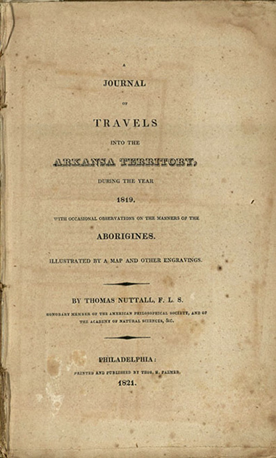
Title page of Nuttall’s Journal of Travels… (1821)
Streeter also donated a pamphlet from the Secretary of the Treasury of the Republic of Texas to President Houston and a Mexican imprint detailing financial transactions after the war with Texas. Streeter included a pamphlet, “Lecture on the Subject of Re-annexing Texas to the United States,” delivered in New Bedford, Massachusetts in 1845. This item gives a well-reasoned argument in favor of annexation from a northern perspective and is unique because most northerners opposed the annexation of Texas as a slave state into the Union. The Baylor Lariat identified the last item, Thomas Nuttall’s Journal of Travels into the Arkansas Territory, as the most valuable in the donation. Even though the work did not directly mention Texas, Streeter still felt it was worthwhile in its description of the territory now adjoining Texas.
Although Streeter did not publish his famed Bibliography of Texas for several more years, his visit to Waco and personal donation remain an important part of the story of The Texas Collection. The library continues to purchase Streeter items today and hopes to enlarge its holdings of these rare items in the years ahead.
Streeter, Thomas W. Bibliography of Texas 1795-1845. Portland, ME: Anthoensen Press, 1955. Reprinted, revised and enlarged by Archibald Hanna with a guide to the microfilm collection Texas as Province and Republic: 1795-1845. Woodbridge, CT: Research Publications, Inc., 1983.
259 years after his birth—give or take a year, as his year of birth is noted as either 1755 or 1757—the world is certainly singing for Alexander Hamilton, and just as these lyrics suggest, the world certainly changed dramatically during his life. But what did the world—especially the world that he knew and helped shape—look like during Alexander Hamilton’s life? Historical maps can show us a certain part of the world at a certain time, and while Texas wasn’t really one of Hamilton’s concerns, The Texas Collection holds some maps that give an interesting perspective on that transformative time in our nation’s history.
A comprehensive depiction of parts of North America in 1752 from the British perspective. 1752 Bowen’s “A new and accurate map of Louisiana”
This first map was created in 1752 by one of the leading English engravers and geographers of the time, Emanuel Bowen. The British colonies are colorfully highlighted in contrast to the much-larger French territory of Louisiana. We can see nearly the entire area that would soon become the United States of America and much of the territory that would eventually join that new country, including an as-yet-unnamed Texas. Keep in mind that this map was drawn from the British perspective—their lands, their colonies, all that for which they would soon be fighting a war.
A comprehensive depiction of more of North America in 1766 from the French perspective. 1766 Desnos’ Nouveau Mexique, Louisiane, Canada, et Nouvelle Angleterre.
This second map is from 1766 and drawn from a French perspective. This map shows most of North America in great detail for the time—though the placement of mountain ranges was clearly speculative, given the long range of mountains stretching through Central Texas. Geographic regions are noted, but political divisions are not the focus of this map. “Nouvelle Angleterre” (French for New England) is depicted as a unified body, which from an outsider’s perspective, it might have appeared to be as it prepared to fight for freedom. Yet we know how the colonies’ individual characteristics and needs played out in the creation of the new nation.
An early depiction of the new United States (Etats-Unis) in 1785, without interior borders. 1785 Wilkinson’s map, United States (Etats-Unis)
The third map, from 1785, is among the first to show the fledgling nation, and most interestingly, the first map to list the proposed states of the Jeffersonian Ordinance of 1784. While this Ordinance ultimately was adopted only partially, this map captures the possibility of what could have been, even while depicting some of what was known of this new nation at that tumultuous time. Note the area out west labeled Grand Espace de Pays Qui N’est Pas Connu (Great Tract of Country Which Is Not Known), where Texas is labelled Tecas.
An accurate depiction of the new United States in 1812, with interior borders. 1812 Wilkinson’s United States
And this last map is from 1812, just a few years after Hamilton’s untimely death in 1804. The mapmaker chose to show only the new United States, with hints of the future acquisitions shown at the western and southern margins. The new country that Hamilton helped to birth was constantly changing, and this is another map that captured a hint of what might have been—regions of Franklinia in present day Tennessee and Indiana in present day West Virginia—had different decisions been made by the leaders of the day.
While most of our map collection has a fixed gaze on Texas and the regions closest to Texas, many of our maps also give insight into other parts of our country, our continent, and the world at large. If these brief glimpses of North America at the time of the American Revolution have piqued your interest, make plans to come by the Texas Collection and visit the map room to see more of our collection.
Click on the image below to view the full Flickr album.