Print Peeks: Exploring the World with the Cosmographia Geographia

By Tiff Sowell, Library Information Specialist

Cosmographia-WoodcutMap
Full-page woodcut map of the world, as it was understood in around 44 C.E.

One of the oldest items in the collection might surprise you, and perhaps raise a few questions such as how and why The Texas Collection became the possessor of this unique volume. Pomponius Mela’s Cosmographia Geographia is often referred to by historians as sive De situ orbis (a description of the known world) due to its falling somewhere between a topography and a geography. Mela works around the Mediterranean Sea, which he calls “our sea,” and while he does not give exact locations as with modern geographies, he does include interesting anecdotes about locals and some of their customs.

Cosmographia-SamplePage
First page of text in the Cosmographia Geographia. Note the use of color and beautifully illuminated initials.

We can date the volume to late 43 or early 44 C.E., as indicated by Mela’s reference to Emperor Claudius’ then recent victory in Great Britain. The text is considered the earliest, still existing geographical work in Latin, and is the only Roman treatise of the classical period devoted entirely to the subject. This was such a groundbreaking piece that it continued to be used well into the Age of Exploration (which starts in the 1400s) and was reprinted numerous times in various methodologies.

The Texas Collection’s copy of this important work was published in Venice in July 1482 by Erhard Ratdolt, a renowned German printer from Augsberg. This would have been just 32 short years after the invention of the printing press. Ratdolt was in Venice from 1476 to 1486 and during that time, he pioneered several firsts in the world of printing, such as the first book using more than two colors, the first full title page, and from what we can discern, the first scientific and mathematic works.

Cosmographia-ProvenanceNote
Provenance note with descriptive bibliographic information about our particular volume of the Cosmographia Geographia.

So what does this have to do with Texas? Not much, unless you were to link it to the early Spanish explorers, supposing some of their conceptions were most likely rooted in this work. So why is The Texas Collection in possession of this landmark geography?  Tracy McGregor established the McGregor Plan in 1932 to assist smaller universities in acquiring rare volumes, and The Texas Collection was one of the libraries selected to participate. This exquisite volume was purchased and remains available to patrons for examination thanks to Tracy McGregor’s generosity.

“Print Peeks” is a regular feature highlighting select items from our print collection.

A Day in the (Texas Collection) Life: John Wilson, Director

Meet John Wilson, originally from Ohio and Director of The Texas Collection, in our last staff post giving you a peek into the day-to-day work of The Texas Collection.

Judge R.E.B. Baylor, drawing by Tom Lea, 1971

When I arrive at work each morning, I am never certain what I will discover, learn, and see. The suspense of unknown waiting treasures provides great enjoyment for me as director of The Texas Collection. I have been in this role a little over three years, and it is an unusual day when I do not receive an email from a donor, a phone call asking a Texas-related research question, or an inquiry from a faculty colleague about some aspect of Baylor’s past.

My day generally begins with reviewing after-hours emails and telephone calls. Once those inquiries have been answered, I try to speak with each one of the staff, then say hello and ask for collection processing updates from our graduate students, and finally try to speak with each of our undergraduate student workers. There are always interesting and new finds from the work our students are accomplishing. These finds might include identifying an early Republic of Texas document with Sam Houston’s signature or discovering that we own an original Tom Lea drawing.

"Old Baylor" at Independence, 2013
Old Baylor at Independence. We worked with UMHB to restore and rededicate the columns in 2013.

I then begin work on two or three pressing projects. This involves multitasking throughout the day. My first project of the day might involve planning or maintenance concerns dealing with Old Baylor in Independence. Once or sometimes twice a month, I travel to Independence to walk the grounds of Windmill Hill or inspect the columns at Academy Hill.  On these trips, I also visit a Baylor graduate or donor and check in with Peggy Ward, who manages the day-to-day operations in Independence and works closely with our community partners, the Independence Historical Society.

In addition to leading and managing The Texas Collection, I work closely with two parts of our extensive holdings, our map collection totaling nearly 17,000 items and photograph collection of more than 1.4 million images. I might review a print or online dealer catalog for both maps and photographs.

New map of Texas with the contiguous American & Mexican states, 1836
“New map of Texas with the contiguous American & Mexican states,” 1836

Another project that might be pressing for my attention is planning a lecture by a guest speaker such as the Honorable Tom Phillips. This type of special event and all of its many details are vitally important to the outstanding reputation and continued outreach necessary to having a vibrant and active special collection. Our speakers have researched in The Texas Collection and connect with our resources and the audience, particularly our students.

On a daily basis, I work with donors to acquire new archival collections that will enhance and strengthen our holdings. We are always searching for early Texas collections from the Spanish Colonial period, the Mexican period, and the early Republic of Texas period. We are also interested in Waco history, the Civil War, Baylor-related items, and of course, print materials dealing with Texas. I am closely involved with the budget, endowments, and fundraising.

One of the most interesting parts of my job is talking with people about The Texas Collection. These days, we talk with and reach out to more people than ever before due to our social media outlets. Flickr, Facebook and this blog are followed and read by fans across Texas and around the world.

I think the most rewarding part of my job is working with Baylor students. This could involve teaching a class, collaborating on a project, or advising students on studying abroad in Italy (another one of my interests). The students are the reason I have stayed at Baylor for 26 years. Our students are smart, talented, and willing to work hard for their Baylor degrees. I am fortunate to work with a great staff and exceptional students.

The Texas Collection turned 90 this year! But even though we’ve been at Baylor for so long, we realize people aren’t quite sure what goes on in a special collections library and archives. So over the course of 2013, we have been featuring staff posts about our work at The Texas Collection. See other posts in the series here. We hope you’ve enjoyed learning more about our work.

A Day in the (Texas Collection) Life: Thomas DeShong, Archival Assistant

Brann-Davis, Waco Daily Telephone
We preserve newspaper clippings such as this one from the William Cowper Brann collection to provide firsthand witness insight into events such as the Brann-Davis shootout in Waco, Texas in 1898.

The Texas Collection turns 90 this year! From 1923, when Waco physician Dr. Kenneth Hazen Aynesworth made his initial donation of materials on Texas history, to 2013, The Texas Collection has grown by leaps and bounds.  But we realize that all too often, people aren’t quite sure what goes on in a special collections library and archives. So over the course of 2013, we will feature monthly posts from our staff—from faculty to student workers—offering a little peek into the day-to-day work of The Texas Collection. (It bears noting that we’re not all originally from Texas, eitherbut as this post notes, there is something for everybody here at The Texas Collection!) Meet recent Baylor grad (M.A. in history), Pennsylvanian, and archival assistant, Thomas DeShong:

When I arrived at Baylor University to further my education, I was largely unfamiliar with the world of archives. As a student of history, I realized that such repositories typically held interesting primary sources just waiting to be cited in the end-of-semester research paper that was inevitably due for each class. However, I was not aware of the multifaceted roles that archivists and librarians perform in order to preserve such history until I found myself with a graduate assistantship at The Texas Collection. Two years later, I am here celebrating the 90th anniversary of the institution while studying to become a certified archivist.

Transcription, Hiram Carlton
Letters written in the 1800s often are difficult for modern researchers to decipher. We can’t afford the time to transcribe all handwritten letters (there are so many!) but make exceptions for important collections like the Hiram Carlton Civil War letters.

There are three primary tasks that I perform as an Archival AssistantDigital Input Specialist at The Texas Collection. The first, which I have enjoyed the most, is processing. Once printed materials have been donated or purchased, it is important to preserve the original documents in the most efficient and effective manner. Papers need to be stored in acid-free folders. Photographs should be housed in clear, Mylar sleeves. Newspaper clippings might be preserved more easily through digitization. Finding aids need to be written so that the public can know about the valuable materials waiting to be researched.  The act of preserving history is fulfilling and exhilarating. The Texas Collection, as its name suggests, houses materials pertaining to Texas history from the Spanish colonial era to the present day. My time here has allowed me to explore collections dealing with Texas governors, the Civil War, Baylor University presidents, missionaries, history professors, inventors, and even the Waco Branch Davidians.

Preservation work is vital to extending the lifespan of materials, but the crux of archival work is making materials accessible to the public. Texas Collection archivists have been appointed the weighty task of maintaining the cultural heritage of Baylor University, the greater Waco area, and Texas. To do this, it is necessary to describe what materials comprise our vast holdings. For the past several months, I, along with many of my co-workers, have been inputting inventories and finding aids into an online archives management system called Cuadra Star. The culmination of this work will occur in the upcoming months as The Texas Collection presents its Cuadra Star database to the public. This effort serves as evidence of The Texas Collection’s persistence in sharing with the public the vast amount of historical resources it can offer.

Waco map
The Frances C. Poage Map Room contains tens of thousands of maps relating to Texas, from early Spanish colonial maps to modern city maps.

My third major responsibility, one that has been recently bestowed upon me, is to manage The Texas Collection’s substantial Frances C. Poage Map Room. With maps ranging from colonial Texas until the twenty-first century, researchers are bound to find something to pique their interests. Most of these maps have now been organized and are searchable on BearCat, the Baylor University Libraries’ online catalog.

Not many people today can claim that they love their jobs, but I certainly can. The Texas Collection has something to offer anyone with the slightest interest in Texas history. I encourage you to celebrate this 90th anniversary with me by coming down and exploring the rich history that The Texas Collection holds!

By Thomas DeShong, Archival Assistant—Digital Input Specialist

Mapping Waco: A Brief History, 1845-1913

Did you know that “Lamartine” was a proposed name for Waco? Or that “Waco Village” was once in Milam County? Do you know where Waco Female College was? Explore Mapping Waco: A Brief History, 1845-1913 to learn the answers to these questions and more.

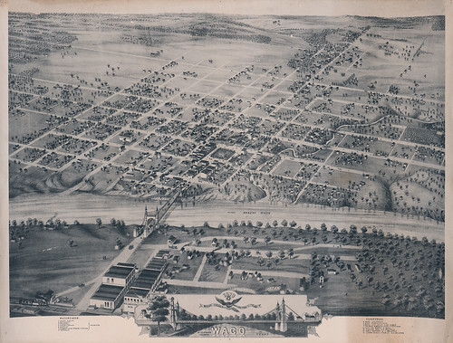
1873 Bird's Eye View of the City of Waco
Bird’s eye view style map of the city of Waco, circa 1873. Lists points of interest including Waco University, Waco Female College, the City Ice Works and the Waco suspension bridge.

In this physical and digital exhibit, maps represent the changing landscape of Waco from its earliest days in the mid-1800s to the boom years of the late 1910s. Selections include bird’s-eye views of the city drawn in the late 19th century; illustrated maps of new additions and suburbs; and blue lines of individual plats on Waco city streets.

“We hope this exhibit of early Waco maps will spark an interest in local geography and history,” said John Wilson, director of The Texas Collection. “It may also begin a dialogue regarding other maps and resources that are in the community and could be shared.”

The maps are on display in The Texas Collection within Carroll Library, which is open from 8-5, Monday through Friday. We hope you’ll come and see them in person AND take a zoomed-in look at them on the Baylor Digital Collections site. The physical and online exhibits are up now and will be on display through December 2012.

We collaborated with the Digitization Projects Group on preparing the digital component of the exhibition–read about the digitization and curation process on Baylor Digital Collections’ blog–and enjoy the maps!

Renovating the Frances C. Poage Map Room

Frances C. Poage

The newly relocated Frances C. Poage Map Room was Archivist Ellen Brown’s brainchild. She thought there needed to be a larger, better organized, user-friendly space for our growing map collection. Room 201 on the 2nd floor of Carroll Library was ideally located for crafting and creating this space. The challenge was keeping the space functional and inviting–not merely drawers of black steel.

While working on the new interior design, we recognized that the character of the 1903 library structure needed to shine forth.  After much effort, the Poage map room has become a happy union of functionality and warmth. The countertops are made of marble that is similar to the original marble used on the entrance steps. The dark cherry wood makes the room seem more like a home library rather than a university map room. The large 9 X 9 foot table anchors the room and invites you to sit awhile in comfortable Windsor chairs and dwell on places you have never been.

Two determined students, Robin and Travis, put the maps in order, preserved them, and protected the fragile ones in Mylar. Once order was returned to the space, thoughts of showcasing some of our maps through an exhibition seemed the next logical step, but we wondered how best to display them. Seeing the first framed map relieved my anxiety about framing.  A 340-year old map was elegantly attired in acid-free matting, UV-protected glass, and a black-gilded framing befitting a Spanish map.  Instead of a tattered bit of paper, the map was a thing of beauty, telling a story about exploration, discovery, heartache, fortunes won and lost.

The “map room project” has been a source of great joy, learning, hard work, and pride. We hope it will be a destination for scholars and Texas enthusiasts for many years to come.

John S. Wilson

Interim Director. The Texas Collection

Mapping it Out: A Cartographic History of Texas

Detail from Mitchell's Map of Texas, 1836

Thursday, October 28th will be a big day here at The Texas Collection. It’s the grand opening of the Frances C. Poage Map Room. We’ll be celebrating with a ribbon cutting, a new exhibit of some beautiful maps, and a special guest lecture from Toby Lester, author of The Fourth Part of the World: The Race to the Ends of the Earth and the Epic Story of the Map That Gave America Its Name.

Our newly installed exhibit is called Mapping it Out: A Cartographic History of Texas. On display are twenty-one original maps dating from 1656 to 1887. These maps tell a story of Texas: from early exploration by the Spanish, through colonization, struggles for independence from Mexico, and statehood before and after the Civil War. They demonstrate technological improvements and record political conflicts. They bring us closer to understanding the craftsmen and entrepreneurs who made it their business to show settlers the way to Texas. And these maps connect us to the land which captured cartographers’ imaginations.

We hope you’ll join us at Carroll Library at 2:30 p.m. on Thursday to celebrate the new Frances C. Poage map room, the art of mapmaking, and the story of Texas.