Texas over Time: Texas State Capitols

Texas has changed quite a bit over the years, as is readily seen in our vast photograph and postcard collections. To help bring some of those changes to life, we’ve created a “Texas over Time” series of GIFs that will illustrate the construction and renovations of buildings, changing aerial views, and more. Our collections are especially strong on Waco and Baylor images, but look for some views beyond the Heart of Texas, too.

TexasStateCapitol

  • Along with Washington-on-the-Brazos and Galveston, Harrisburg served as one of Texas’ temporary capitals. President David G. Burnet convened the provisional government at the John R. Harris home (image 1) in 1836.
  • Columbia was the first capital of an elected government of the Republic of Texas, but that lasted only from October-December 1836. The second capital of the Republic of Texas was in Houston, Texas (1837–1839, 1842). Sam Houston’s executive mansion and Harris County court house is pictured in image 2.
  • The modern-day Capitol in Austin, Texas, was constructed between 1882 and 1888 after there being a few prior buildings. A building commission was implemented, and Elijah E. Myers won the competition for the architecture design. Construction began in 1882, the corner stone was laid March 2, 1885 and it was ready for use in 1888. The building was built entirely of “sunset red” granite from quarries near Marble Falls, Texas.
  • At its initial construction, the capitol had 392 rooms, 924 windows and 404 doors. It is 311 feet tall, beating out the U.S. Capitol (288 feet), just by the height of the “Goddess of Liberty” statue that stands atop the dome.
  • The original zinc Goddess statue weighed almost 3,000 pounds. In 1986, it was taken down and replaced by a lighter aluminum version. The statue is now on display at the Bob Bullock State History Museum.

Image 1: John R. Harris home, Harrisburg, Texas (one of several Texas capitol locations in 1836)

Image 2: Sam Houston’s executive mansion in Houston, and the second capital of the Republic of Texas (1837-1839, 1842)

Image 3: First capitol in Austin (and the only capitol for the Republic of Texas and the State of Texas), 1839–1856

Image 4: Second capitol in Austin, built 1856, burned 1881

Image 5: Third capitol in Austin, completed 1888

Sources

Handbook of Texas Online, William Elton Green, “Capitol,” accessed April 21, 2016, http://www.tshaonline.org/handbook/online/articles/ccc01.

Handbook of Texas Online, John G. Johnson, “Capitals,” accessed May 12, 2016, https://tshaonline.org/handbook/online/articles/mzc01.

“The Goddess of Liberty.” SenateKids. Texas Senate Media Services, 1998. Web. 21 Apr. 2016.

GIF and factoids by Haley Rodriguez, archives student assistant. See these Texas State Capitol images in our Flickr set.

Texas over Time: Carroll Library, Baylor University, Waco

Texas has changed quite a bit over the years, as is readily seen in our vast photograph and postcard collections. To help bring some of those changes to life, we’ve created a “Texas over Time” series of GIFs that will illustrate the construction and renovations of buildings, changing aerial views, and more. Our collections are especially strong on Waco and Baylor images, but look for some views beyond the Heart of Texas, too.

CarrollLibrary• Home to the first library at Baylor University and The Texas Collection, the plans for the construction of F. L. Carroll Library were introduced in 1901 and the then Chapel and Library were completed in 1903.
• The Chapel and Library was a gift from F. L. Carroll and along with the Carroll Science Hall (funded by F.L.’s son, G.W. Carroll), the Lariat announced their constructions under the headline “Greater Baylor Begins.”
• The first floor housed the library with special book collections donated by several individuals, including Dr. A. J. Armstrong. The chapel was located on the second floor of the building covered by a dome and decorated with stained glass windows.
• On February 11, 1922, the Chapel and Library caught fire from an unknown source and destroyed the majority of the interior. Many students and faculty risked their safety to retrieve the library’s books and documents, saving over half of the total collection.
• The building was renovated between 1922 and 1924; the chapel was not reconstructed and a third floor took its place.  A basement was also added to the renovations, and many of the original stone and brickwork were kept intact on the architecture.
• With the building running out of room, the central library was moved to the new Moody Memorial Library in 1968.
• Over the years, various departments, the Strecker Museum, and the J. B. Tidwell Bible Library were located at Carroll Library for brief periods of time.
• In 1992, a severe hail storm damaged many of the windows so the building was once again renovated and fully functional in 1994.
• As of 2016, the building houses The Texas Collection, the Institute for Oral History, the Keston Center for Religion, Politics, and Society, and the J.M. Dawson Institute of Church-State Studies.

Sources

Fiedler, Randy. “The Carroll Library Fire.” Baylor Magazine. Baylor University, Fall 2015. Web. 24 Mar. 2016.

Amanda Dietz, “F. L. Carroll Chapel and Library,” Waco History, accessed March 24, 2016.

GIF and factoids by Haley Rodriguez, archives student assistant. See these and other images of Carroll Library in our Flickr set.

Texas over Time: Big Bend National Park–The Window

Texas has changed quite a bit over the years, as is readily seen in our vast photograph and postcard collections. To help bring some of those changes to life, we’ve created a “Texas over Time” series of GIFs that will illustrate the construction and renovations of buildings, changing aerial views, and more. Our collections are especially strong on Waco and Baylor images, but look for some views beyond the Heart of Texas, too.

window

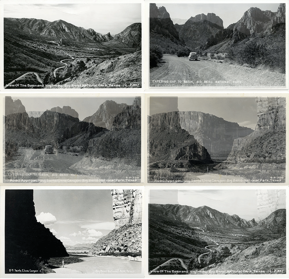
  • Being directly on the United States-Mexico border, Big Bend has been the landmark of several different disputes between Mexico and the U.S. On May 5, 1916, Mexican raiders and American soldiers fought a three-hour battle in the town of Glenn Springs, which is now a popular spot in Big Bend’s park.
  • As a part of the Civilian Conservation Corps (CCC) under President Franklin D. Roosevelt’s New Deal, thousands of young men were given employment by carving out the seven-mile access road, “using only picks, shovels, rakes and a dump truck” into the Chisos Mountains Basin.
  • With only 1,409 visitors in its first year, Big Bend now has an annual record of over 300,000 visitors.
  • The Window frames panoramic views of the canyon and is a popular location at sunset. It is made from the rock canyon that cuts through the Chisos Mountains rim.

Sources

“Chihuahuan Desert.” – DesertUSA. Digital West Media Inc., n.d. Web. 05 Feb. 2016. <http://www.desertusa.com/chihuahuan-desert.html>.

“Texas’ Gift to the Nation.” National Park Service. U.S. Department of the Interior, n.d. Web. 5 Feb. 2016. <http://www.nps.gov/bibe/learn/historyculture/tgttn.htm>.

“Big Bend National Park Mountain Hikes.” National Parks Service. U.S. Department of the Interior, 03 Feb. 2016. Web. 05 Feb. 2016. <http://www.nps.gov/bibe/planyourvisit/mountain_hikes.htm>.

“Big Bend National Park.” National Geographic. National Geographic Partners, LLC., n.d. Web. 05 Feb. 2016. <http://travel.nationalgeographic.com/travel/national-parks/big-bend-national-park/>.

GIF and factoids by Haley Rodriguez, archives student assistant. See these and other images of Big Bend in our Flickr set.

Texas over Time: Big Bend National Park–Santa Elena Canyon

Texas has changed quite a bit over the years, as is readily seen in our vast photograph and postcard collections. To help bring some of those changes to life, we’ve created a “Texas over Time” series of GIFs that will illustrate the construction and renovations of buildings, changing aerial views, and more. Our collections are especially strong on Waco and Baylor images, but look for some views beyond the Heart of Texas, too.

santa-elena-canyon

  • Big Bend is one of the United States’ most remote national parks and is located in the southwest part of Texas. It is 801,163 acres and was established in June 12, 1944, under President Franklin D. Roosevelt.
  • The Spaniards originally named the area “El Despoblado,” the uninhabited land.
  • Big Bend is named after the winding path of the Rio Grande River that runs throughout the park, dividing it into massive canyons and straddling the U.S.-Mexico border.
  • The Chihuahuan Desert rests partly inside Big Bend’s borders and is the largest desert in North America. This ecosystem helped establish Big Bend as an International Biosphere Reserve, which can allow for future environmental research
  • Until the mid-1960s, Santa Elena Canyon (pictured in the GIF) was formally known as “Santa Helena Canyon.” English-speaking visitors were not pronouncing the name correctly, so the National Park Service dropped the H from the name to assist with the proper Spanish pronunciation.

GIF and factoids by Haley Rodriguez, archives student assistant. See these and other images of Big Bend in our Flickr set.

Sources

“Chihuahuan Desert.” – DesertUSA. Digital West Media Inc., n.d. Web. 05 Feb. 2016. <http://www.desertusa.com/chihuahuan-desert.html>.

“Texas’ Gift to the Nation.” National Park Service. U.S. Department of the Interior, n.d. Web. 5 Feb. 2016. <http://www.nps.gov/bibe/learn/historyculture/tgttn.htm>.

“Big Bend National Park Mountain Hikes.” National Parks Service. U.S. Department of the Interior, 03 Feb. 2016. Web. 05 Feb. 2016. <http://www.nps.gov/bibe/planyourvisit/mountain_hikes.htm>.

“Big Bend National Park.” National Geographic. National Geographic Partners, LLC., n.d. Web. 05 Feb. 2016. <http://travel.nationalgeographic.com/travel/national-parks/big-bend-national-park/>.

Texas over Time: Texas Christian University, Waco campus fire–before and after

Texas has changed quite a bit over the years, as is readily seen in our vast photograph and postcard collections. To help bring some of those changes to life, we’ve created a “Texas over Time” series of GIFs that will illustrate the construction and renovations of buildings, changing aerial views, and more. Our collections are especially strong on Waco and Baylor images, but look for some views beyond the Heart of Texas, too.

TCUDid you know that Texas Christian University was in Waco for about 15 years? Images can be found in the general photo files (Waco–TCU)

  • Founded in 1873 by Addison and Randolph Clark, and formerly known as Add-Ran College, TCU was originally located at Thorp Spring (Hood County). In 1890, the university obtained new ownership by the Disciples of Christ.
  • When the Waco Female College closed, the Christian Church of Waco promised to give TCU the building if they relocated their school to Waco, along with $5,000 and fifteen acres of land. They relocated in December 1895.
  • In 1902, the school’s second president, E.V. Zollars was elected. Almost immediately, there was a vote to change the name of the school to Texas Christian University, with the AddRan name used for the AddRan College of Arts and Sciences.
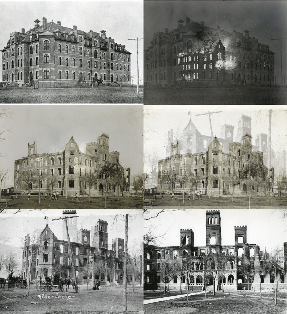
  • On March 22, 1910, a fire destroyed the main building of the college, which was used for academic purposes as well as for dormitory space. Students living on the top floor had to abandon all their belongings. Wacoans offered their homes to house the displaced students, and Baylor offered its classrooms, libraries, laboratories, etc.,
  • By May 1910, the school’s leadership decided to move to Fort Worth. Waco, McKinney, Gainesville, Dallas, and Fort Worth all submitted bids for TCU to help rebuild the school, but Fort Worth’s bid offered the most financial incentive and other support.

Works Cited

Kelley, Dayton. “Texas Christian University.” The Handbook of Waco and McLennan County, Texas. Waco: Texian, 1972. 262-63. Print.

Moore, Jerome Aaron. Texas Christian University: A Hundred Years of History. Fort Worth: Texas Christian University Press, 1974. Print.

GIF and factoids by Haley Rodriguez, archives student assistant. See these  images in our Flickr set. More information about TCU in Waco can be found on the Waco History app website.


Texas over Time: Austin Avenue from City Hall, Waco

Texas has changed quite a bit over the years, as is readily seen in our vast photograph and postcard collections. To help bring some of those changes to life, we’ve created a “Texas over Time” series of GIFs that will illustrate the construction and renovations of buildings, changing aerial views, and more. Our collections are especially strong on Waco and Baylor images, but look for some views beyond the Heart of Texas, too.

AustinAveOur readers may remember that we did a GIF of Waco’s Austin Avenue awhile back, looking at City Hall. Now, we look the other direction! A few facts about the buildings/businesses you see in this GIF…

  • ALICO Building: Construction for the Amicable (ALICO) Building began in 1910 and after a height competition with the Adolphus Hotel in Dallas, it was decided that the building would be 22-stories high. The builders, Sanguinet and Staats of Forth Worth and Roy E. Lane of Waco, wanted the building to have a structure that could sustain disaster, so a steel frame was put into place, and this was proved worthwhile after the 1953 tornado. The Texas State Historical Commission named the ALICO building a historical landmark in 1982.
  • Roosevelt Hotel: Before it became the Roosevelt Hotel, local civic leader Peter McClelland built the McClelland Hotel in 1872. The property was purchased by Conrad Hilton of the international chain, Hilton Hotels and Resorts. The economic downturn of the Great Depression caused Hilton to sell the property in 1934 to local investors, where it finally became known as the Roosevelt Hotel, honoring President Franklin D. Roosevelt. The Roosevelt was one of the three buildings in the storm’s path that stood strong during the 1953 Waco tornado. Its steel frame supported the structure but for the businesses that did not survive, the owners relocated to the suburbs and the Roosevelt Hotel was forced to close in 1961. After its life as the Regis Retirement Home, local builder Mike Clark bought the building in 2004 and the space was renovated to accommodate event rentals, restaurants, and offices.
  • W.P. Pipkin Drugs: One of the Southwest’s largest independently owned drugstore chains, the W.P. Pipkin Drug store was successfully run by William Pipkin and then after his death, it was run by his daughter, Pauline Pipkin Garrett. Pipkin was the first drugstore owner to hire women and in a time where opportunities for women were limited, Garrett exceeded these expectations by expanding her father’s business into a thriving enterprise throughout Waco. Pipkin Drugs had seven locations.
  • Sanger Bros./Montgomery Ward: The Sanger Brothers open their shoe store on the square between Austin Avenue and Bankers’ Alley on March 4, 1873. Their store later moved between Fourth and Fifth Street on Austin Avenue. Products the store sold included “dry goods, clothing, boots, shoes, hats, caps, gents’ furnishing goods, carpets, and oil cloths,” per an ad by the Waco Daily Examiner. The business was very successful up until Sam Sanger’s death in 1919. In its final days thousands of dedicated customers were reported to show up for the last sales.

Bibliography

Kyle Baughman and Amanda Sawyer, “Amicable (ALICO) Building,” Waco History, accessed October 9, 2015, http://wacohistory.org/items/show/23.

Geoff Hunt, “Pauline Pipkin Garrett,” Waco History, accessed October 9, 2015, ffghttp://wacohistory.org/items/show/101.

Amanda Sawyer, “Sanger Brothers Department Store,” Waco History, accessed October 9, 2015, http://wacohistory.org/items/show/85.

Amanda Sawyer, “Roosevelt Hotel,” Waco History, accessed November 4, 2015, http://wacohistory.org/items/show/41.

GIF and factoids by Haley Rodriguez, archives student assistant. See these and other images of Austin Avenue in our Flickr set.

Texas over Time: Waco Suspension Bridge

Texas has changed quite a bit over the years, as is readily seen in our vast photograph and postcard collections. To help bring some of those changes to life, we’ve created a “Texas over Time” series of GIFs that will illustrate the construction and renovations of buildings, changing aerial views, and more. Our collections are especially strong on Waco and Baylor images, but look for some views beyond the Heart of Texas, too.

Waco Suspension Bridge

  • Opened to the public on January 7, 1870, the 475-foot structure is one of downtown Waco’s iconic landmarks.
  • At the time of its completion, it was the longest single-span bridge west of the Mississippi.
  • The cables and steelwork were supplied by John Roebling Co., who also helped build the Brooklyn Bridge in New York City during that decade
  • As the only bridge over the Brazos River, it brought much publicity to Waco, helped local economic stimulation and served as a public bridge starting in 1889.
  • During times of high water, the bridge was used greatly for moving cattle herds.
  • In 1914, it went under total reconstruction including a brand new cable system; the roadway is now supported with steel and the towers were remodeled with stucco.
  • In July 1970, it became the first Waco site on the National Register of Historic Sites.

Sources

Roger N. Conger, “The Waco Suspension Bridge,” Texana, I (Summer 1963); Minute  Books of the Waco Bridge Company (MS., Waco-McLennan County Library).

“The City of Waco.” Suspension Bridge & Riverwalk, Parks & Recreation. City of Waco Municipal Information, n.d. Web. 28 Sept. 2015.

Smyrl, Vivian Elizabeth. “Waco Suspension Bridge.” Texas State Historical Association. TSHA, University of Texas, 15 June 2010. Web. 28 Sept. 2015.

GIF and factoids by Haley Rodriguez, student archives assistant. Learn more about the history of the suspension bridge in our YouTube video and see these images in our Flickr album.

Texas over Time: Baylor Homecoming parade, 1953

Texas has changed quite a bit over the years, as is readily seen in our vast photograph and postcard collections. To help bring some of those changes to life, we’ve created a “Texas over Time” series of GIFs that will illustrate the construction and renovations of buildings, changing aerial views, and more. Our collections are especially strong on Waco and Baylor images, but look for some views beyond the Heart of Texas, too.

Something a little different this month–attend the 1953 Baylor Homecoming parade!

Baylor Homecoming paradeViews from the 700 block of Austin Avenue of the October 31, 1953 parade. A devastating F5 tornado hit just a few blocks from this site on May 11 of the same year.

  • In 2012, Baylor Homecoming was declared by the Smithsonian to be the first collegiate Homecoming celebration. On November 24, 1909, about 60 decorated carriages and cars and about 70 walking groups made their way down Washington Avenue towards Eighth and Austin, then made their way to campus for the football game at Carroll Field. As the Baylor band led the way, organizations from across campus, sports teams, and societies participated in the parade.
  • Although the first Homecoming was a success, it was held sporadically and did not become an annual tradition until the late 1940s.
  • In the second Homecoming in 1915, we start to see a few floats in the parade. In 1960 floats  began to carry themes of Baylor defeating (and otherwise destroying) their opponent for the big football game.
  • The route for the parade has gradually evolved and in recent years has started on Austin Avenue and ended on Fifth Street, in the heart of campus.
  • In addition to the parade, Homecoming features many other activities and traditions, including alumni dinners and reunions, a bonfire in Fountain Mall, the Freshman Mass Meeting, Pigskin Revue, and Friday Night Flashback.
  • For Homecoming 2015, Baylor will dedicate the Rosenbalm Fountain on the new Fifth Street promenade. Students, alumni and faculty will get to experience an over 100-year tradition while making a brand new one in the process.

Sources:

“Homecoming Parade.” Baylor University. Baylor University, n.d. Web. 22 Sept. 2015.

Morris, Conner. “The Great School of Which I Have Dreamed: Homecoming 2014.” Our Daily Bears. SB Nation, 28 Oct. 2014. Web. 22 Sept. 2015.

See all of the images in our Flickr set–and there are several more Homecoming albums on our Flickr page, too! GIF and factoids by Haley Rodriguez, archives student assistant.

Texas over Time: Lake Waco

Texas has changed quite a bit over the years, as is readily seen in our vast photograph and postcard collections. To help bring some of those changes to life, we’ve created a “Texas over Time” series of GIFs that will illustrate the construction and renovations of buildings, changing aerial views, and more. Our collections are especially strong on Waco and Baylor images, but look for some views beyond the Heart of Texas, too.

Lake-Waco-GIF

  • Lake Waco was originally created by a dam on the Bosque River in 1930 that cost $2.5 million.
  • The dam was rebuilt in 1964 for a cost of $48 million. Then-Senator Lyndon B. Johnson presided over the groundbreaking that was truncated due to a severe thunderstorm. The new dam was 140 feet high and expanded the lake to a surface area of 7,000 acres.
  • All of the land for the lake expansion was acquired through a willing-seller willing-buyer basis at contemporary market rates. Eminent domain was not used.
  • The lake sits on land that is made up of limestone, shale, and chalk deposits. The lake, as well as the area immediately around it, is an archaeologically significant site, as artifacts from several thousands of years of Native American habitation have been found there, as well as artifacts from early European settlement of the McLennan County area.

Sources:

Lake Waco Clippings 1930-1961 vertical file, The Texas Collection, Baylor University.

Scott, Ann M., Karl W. Kibler, and Marie E. Blake. “National Register Testing of Nine Archeological Sites at Waco Lake, McLennan County, Texas.” Austin: Prewitt and Associates, 2002.

If you’re interested in learning more about efforts to control Texas rivers, join us on October 22 to hear Kenna Lang Archer’s presentation on her book, Unruly Waters, which explores the history of the Brazos River.

See all of the images in our Flickr set. GIF and factoids by Braxton Ray, archives student assistant.

Texas over Time: Congress Avenue, Austin

Texas has changed quite a bit over the years, as is readily seen in our vast photograph and postcard collections. To help bring some of those changes to life, we’ve created a “Texas over Time” series of GIFs that will illustrate the construction and renovations of buildings, changing aerial views, and more. Our collections are especially strong on Waco and Baylor images, but look for some views beyond the Heart of Texas, too.

Austin-NorthCongressA few notable superlatives centered around Austin’s Congress Avenue…

  • The Bosche-Hogg building was the site of the first steam laundry west of the Mississippi, circa late 1890s.
  • At nine stories, the Littlefield building (c. 1912) was briefly the second tallest building west of the Mississippi behind the ALICO, which was completed the year before, in 1911. (Many Austin sources state it as being the tallest, despite it being shorter than and built later than the ALICO.)
  • The street was home to a mule powered streetcar line starting in 1875. It was later upgraded to an electric line. The street was the first in Austin to be paved, in 1905, reportedly causing horses and buggies to fall whenever it rained, as they weren’t used to making fast turns on the pavement.
  • The Angelina Eberly/Texas Archives War statue (between Sixth and Seventh Streets) is one of the only public sculptures celebrating archives. Eberly is depicted firing a cannon to alert the people of Austin (in 1842) that Sam Houston’s men were stealing the Republic of Texas’ archives, part of President Houston’s efforts to relocate the capitol to Houston. Eberly, who ran a boarding house, fired off a grapeshot load from a cannon, sending soldiers on their way to head off the records thieves and ultimately, preserve Austin as the state capitol.

Sources:

Castle, Melissa Allen. Austin Through a Century: Know Your Capitol. Austin: S.n., 1939. Print.

Historic Walking Tours: Congress Ave. & E. 6th St. Austin, TX: Visitor Information Center, 1995. Print.

Hodges, Rob. “Angelina (Peyton) Eberly—A Pioneering Spirit.” Texas Historical Commission, 2013. http://www.thc.state.tx.us/blog/angelina-peyton-eberly-pioneering-spirit. Web.

Humphrey, David C. Austin: A History of the Capital City. Austin: Texas State Historical Association, 1997. Print.

Jackson, Pearl Cashell. Austin Yesterday and Today: A Glance at Her History, a Word about Her Enterprises, a Description of Her Big Banking Establishment. Austin, TX: E.L. Steck, 1915. Print.

Shelton, Emmett. My Austin: Remembering the Teens and Twenties. Boston, MA: American, 1994. Print.

See all of the images in our Flickr set. GIF and factoids by Braxton Ray, archives student assistant.