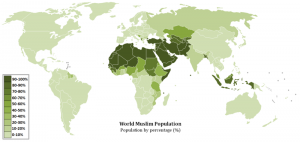
The third area we want to look at is maps. Maps are an interesting primary source because they can show where something is located. This fact can help uncover interesting things about the topic. Think about how Geography shapes the way we live and this topic.

CC Image courtesy of TheGreenEditor via Wikimedia Commons: http://commons.wikimedia.org/wiki/File:World_Muslim_Population_Map.png
- Where does the Muslim population seem to be concentrated?
- Do you know where it started?
- What aspects influenced the Islamic religion?
- Why might it have spread and stayed in some places?
- Why might it not have spread or stayed in some places?

CC Image courtesy of Woman Stats Project via Wikimedia Commons:
http://womanstats.org/data/images/map3.10requireddresscodesforwomen_compressed.jpg
- Where is dress code most harsh?
- Why might it be strict?
- What is the relationship of the countries with a high percentage of Muslims and dress code?
- How does culture and religion influence dress codes?
- How do you think Muslim women feel about these dress codes?

CC Image courtesy of Hardscarf via Wikimedia Commons:
http://commons.wikimedia.org/wiki/File:Countries_with_Sharia_rule.png
- What is Shari’a law?
- Do all countries with a Muslim population enforce Shari’a law?
- How does it relate to the Islamic religion?
- Where does it appear the most prominent?
- Why might it be strong there?
- How would you justify Shari’a law in these countries?
