Part III: The Red River Resolution: Defining the Border Once and for All

by Rachel DeShong, Special Event Coordinator and Map Curator

This blog post is the third and final post in a series of three highlighting John Melish, a 19th century cartographer, and the impact his 1816 map,  Map of the United States with the Contiguous British & Spanish Possessionshad on U.S. history.

As the United States acquired significant territory through the 1840s and 1850s, borders between newly admitted states followed boundaries established in the Adams-Onís Treaty of 1819. Border disputes between states emerged as a result of several inaccuracies in Melish’s map. One particular hotbed of contention was the Red River area.

According to the Adams-Onís Treaty, the boundary between the Spanish colony of Mexico and the United States began at the mouth of the Sabine River, went north to the 32nd degree latitude line where it intersected with the Red River, and then followed that river west until it reached the 100th Meridian. However, there were several problems with Melish’s depiction of the area. Firstly, his 100th Meridian was off target by nearly 90 miles. Secondly, Melish only recorded a single fork in the Red River while, in actuality, there were two. These errors became problematic in deciphering the border between Texas and the Indian Territory (Oklahoma).

Continue Reading

Part I: Why Do Baptists Care About Religious Liberty?

by Thomas DeShong, Project Archivist

This blog is the first of two that highlights a recently processed collection, the Baptist Joint Committee records, and its place in history.

Of all the rights and freedoms guaranteed to American citizens by the U.S. Constitution and the Bill of Rights, freedom of religion has proven to be one of the mostly hotly contested.  Throughout the history of the United States, stretching back to the early years of British colonization in the seventeenth century, religious liberty has been at times both staunchly protected and unequivocally denied.  Baptists, due in part to the histories of their denominations, have often stood as key proponents of religious liberty for all.Continue Reading

John N. Rowe III Papers: A Texas Treasure

by Benna Vaughn, Manuscripts Archivist

In the late 1980s and early 1990s, The Texas Collection was the recipient of eight separate donations of materials from John N. Rowe, III. These donations collectively became the John N. Rowe III papers. Rowe, renown numismatist and collector from Dallas, began collecting bank notes as a small boy, and what began as a hobby became a life-long passion. This collection represents that passion and is steeped in Texas and Mexican history.

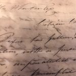
It isn’t every day that an archivist works with a collection that causes “oohhs” and “aahhs” with every turn of the page. The John N. Rowe, III papers are such a collection. It contains so much early Texas and Mexican history that it is hard not to stop and read every document. One of the most fascinating items in the papers is dated October 11, 1835, written to General Stephen F. Austin, and begins like this:

Bexar has fallen! Our brave citizen volunteers, with a persevering bravery and heroic valor, unparalleled in the annals of warfare, have triumphed over a force of twice their number and compelled the slaves of despotism to yield, vanquished by the ever resistless arms of freemen soldiers.

Now, if you are a Texan, that’ll wake you up in the morning! And just holding the letter, turned dark and torn in places, gives you goosebumps. It brings alive the feeling and zeal of the Texas Revolution.Continue Reading

Part II: Compromise Leads to Conflict: The Adams-Onís Treaty

by Rachel DeShong, Special Event Coordinator and Map Curator

This blog post is the second in a series of three posts highlighting John Melish, a 19th century cartographer, and the impact his 1816 map,  Map of the United States with the Contiguous British & Spanish Possessionshad on U.S. history.

John Quincy Adams
Popular Graphic Arts, Prints & Photographs Division, Library of Congress, LC-DIG-pga-10486.

The Adams-Onís Treaty of 1819 was the culmination of prolonged boundary disputes between Spain and the United States. Spain was attempting to retain their colonial empire in the Americas which was crumbling at the hands of revolutionaries. The United States, on the other hand, was rapidly expanding its borders but was highly concerned about the British presence in Florida. Although officially recognized as Spanish territory, Florida was heavily influenced by British mercantilism. During the War of 1812, British naval vessels used Florida as a launching point for attacks on New Orleans and other ports of the American South. Moreover, the United States had growing concerns regarding the number of runaway slaves and Native Americans residing in Florida. For these reasons, both Spain and the United States sought a mutually beneficial compromise with Florida at the heart of the deal.

Luis de Onís y Gonzalez was the Spanish Foreign Minister who negotiated the treaty. Arriving in Washington, D.C. in October 1809, he was not recognized as a legitimate government representative at first due to a civil war in Spain. It was not until December 1815 that the United States formally accepted Onís’ credentials. Although negotiations commenced under Secretary of State James Monroe (before he became the fifth president), most of the results occurred under Secretary of State John Quincy Adams (who would become the sixth president.) After the finer points were settled, the Adams-Onís Treaty accomplished two of the Unites States’ major priorities:

  1. Spain ceded Florida to the United States.
  2. The United States now claimed a solid, international boundary extending from the American South to the Pacific Northwest.

Continue Reading

Women’s Collections at Baylor University

by Anna Redhair, Graduate Assistant

In honor of Women’s History Month in March, Baylor University Libraries Special Collections and the Institute for Oral History launched a website for researching the various women’s collections and oral memoirs held across campus. The website includes materials from the Institute for Oral History; Armstrong Browning Library and Museum; Central Libraries Special Collections; Keston Center for Religion, Politics, and Society; The Texas Collection; and W. R. Poage Legislative Library.Continue Reading

Texas Over Time: “The Raleigh Building, Waco, TX”

Texas has changed quite a bit over the years, as is readily seen in our vast photograph and postcard collections. To help bring some of those changes to life, we’ve created a “Texas over Time” series of Meta Slider’s that will illustrate the construction and renovations of buildings, street scenes, and more. Our collections are especially strong on Waco and Baylor images, but look for some views beyond the Heart of Texas, too.

The Raleigh Building, Waco, TXContinue Reading

Research Ready: April 2018

Each month, we post an update to notify our readers about the latest archival collections to be processed and some highlights of our print material acquisitions. These resources are primed for research and are just a sampling of the many resources to be found at The Texas Collection!Continue Reading

Part I: The Lines are Drawn: John Melish and His Map of the United States

by Rachel DeShong, Special Event Coordinator and Map Curator

This blog post is the first in a series of three posts highlighting John Melish, a 19th century cartographer, and the impact his 1816 map,  Map of the United States with the Contiguous British & Spanish Possessionshad on U.S. history.

Although John Melish is not a name most people are familiar with, his map entitled Map of the United States with the Contiguous British & Spanish Possessions (1816) played a significant role in American history. Maps were often critical to international diplomacy, and inaccuracies usually led to conflict.Continue Reading