If you’ve followed our blog for awhile, you may recall a post about the special digitization equipment we utilize here at the Riley Digitization Center, including our large format map scanner, the Cruse CS-285. Well, the “big guy” got a workout this past summer when we digitized a number of rare and interesting maps from The Texas Collection in preparation for a joint physical and digital exhibit entitled “Mapping Waco: A Brief History, 1845-1913.”
The exhibit, which will be open at the Carroll Library on campus through December, features 11 maps from the earliest days of Waco and explores the development of our fair city’s boundaries as they extended beyond the original plot of land surveyed and staked by George B. Erath and Neil McLennan.
Maps featured in the exhibit include an 1845 “Map of Texas from the most recent authorities,” an 1873 Bird’s Eye View of the City of Waco and a 1913 Map of Waco, Texas and Suburbs. Each map is a fine example of the cartographer’s art, and true buffs will find much to intrigue them whether in person at The Texas Collection or via the digital exhibit presented via our Digital Collections.
Digitization and Exhibit Creation Process
The maps were scanned on the Cruse at a minimum of 300 dpi, with smaller maps scanned at higher resolutions. The Texas Collection’s staff delivered the maps in either Mylar folders or rolled in archival-safe tubes and Digitization Projects Group staff scanned them over the course of several weeks earlier this year. The files were checked for stability and backed up to our preservation server and other off-campus storage solutions before the originals were returned to The Texas Collection, and the process of adding the materials to CONTENTdm began.
Creating the digital records included attaching cataloging metadata to the maps, and for that we relied on information retrieved from BearCat, the university’s digital cataloging system. As we were putting together the digital exhibit, we added text and other information generated by staff at The Texas Collection to mirror the wording printed for labels for the physical exhibit, thus ensuring that visitors to either version of the exhibit would see the same information about each map.
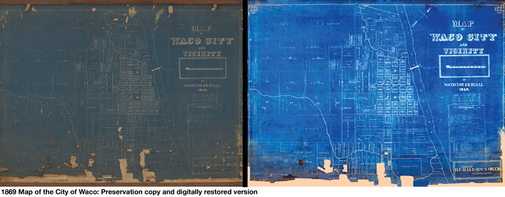
To add some extra features to the digital component of the exhibit, we turned to two popular online tools, Flickr and GoogleMaps. For the Flickr content, we chose eight maps from the exhibit and digitally enhanced them to give users an idea of what the maps might have looked like when they were first printed. (As a rule, we do not enhance or otherwise alter the items in our Digital Collections, preferring to present them as they appear today. Enhancements are reserved for special cases like this exhibit’s Flickr stream.)
Here, you can see the difference between the current state of the 1869 map of Waco and its digitally reconstructed version, presented via Flickr.
We also wanted to give people a sense of how the maps looked compared to current maps of Waco, so we used the GIS data presented via GoogleMaps to overlay the boundaries of the historic maps with their modern-day contemporaries. Here, you can see the way the Farwell Heights Addition to Waco Map relates to the current map of Waco. We also added points of interest listed in the original map which are no longer extant today, including a proposed car shed for an electric street car line and the site of the Waco Female College.

*****
We hope you’ll take some time today to click over and explore this unique exhibit. It will give you a deeper appreciation of the changing landscape of Waco’s streets and buildings, and – we hope – a feel for how digital and physical exhibits can work together to present information to visitors in-person and online. Special thanks to our colleagues at The Texas Collection for their invaluable contributions to the exhibit, and to the DPG staffers and student workers who digitized the maps.
View the Flickr Set of Digitally Enhanced Maps
Visit The Texas Collection’s Website
“Mapping Waco: A Brief History, 1845-1913” is a joint exhibit of The Texas Collection and the Digitization Projects Group and will be available in person and online through December 2012.
UPDATE: November 7, 2012
Our friends at The Texas Collection have written a blog post about the exhibit as well. You can view it via their blog.

